If the Kansas City Royals want to move downtown, why put a horrible location on the ballot?
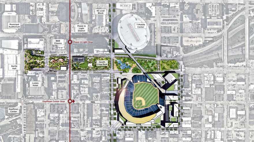
The crossroads is a location that requires destroying buildings and businesses that helped redevelop the area. They kept teasing us with an east village plan only to do a shady last minute change.
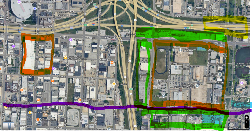
If they want the crossroads, go east of 71. Check this out: a 4×4 block area vs. a 3×3 block area. That’s 12 vs. 9 square blocks. Actually, 4x the size.
Benefits!!!
- Close to P&L
- Doesn’t destroy Businesses
- Mostly City owned property
- KCATA bus barn (16.17 Acers + 3.36 in empty land= 19.53 Acers)
- KC Schools VoTech Campus “KCPS: Manual Career Tech Center”. The Royals promised funding for KC Schools, and were going to pay dozens of businesses to move, how about build a state-of-the-art VoTech campus on one of hundreds or dozens of Vacant KC Public School properties, and let the thriving businesses continue as is vs telling businesses we don’t care about all the hard work you did not only to survive, but to redevelop a depressed area (The crossroads 2000-present). (16.48 Acres Including fields)
- 1.74 Acres Full Employment Council + a vacant city park with unmarked acres
- .72 acres for KC P&L/Evergy
- 38.47 Total Acres, not counting 4.74 acres along the NE edge for a school, church, and two businesses.
- VS The proposed 18-acre development spanning from Grand Boulevard east to Locust Street, and Truman Road south to 17th Street.
- VS One Pershing Square Location at 2301 Main St (6.14 acres)/Washington Square Park (4.75 acres) at 100 E Pershing Rd, Kansas City, MO 64108 (2301 Main St. Previous headquarters for Blue Cross and Blue Shield of Kansas City) Total Acres: 10.89 acres. Directly connected to Main Street Street-Car line, and KC Terminal Railway, but not near or directly connected to ANY highways. Also cuts off OK St, and potentially Grand Blvd, based on the renderings. OK St is a main supply line to Union Station, and bypass for events on Main, Grand, and Pershing Streets.
- 18th and Vine Brings baseball back to its roots:
- The KC Municipal Stadium was 4 blocks south, and 7 blocks east
2123 Brooklyn Ave, Kansas City, MO 64127 - The Baseball Museum is immediately across Paseo, and moving west to be directly south of 18th street
- The KC Municipal Stadium was 4 blocks south, and 7 blocks east
- Within a block of a Major entertainment district 18th and Vine, while still within 6 blocks of the previously proposed crossroads location
- 10 Times better highway access:
- East and West I-70 exits from Paseo (Northeast edge of project)
Plus other exits off of I-70 east along Truman as well as 18th St, 21st St, and 23rd St
(East and South edges of project) - 9 blocks straight south off of Southbound I35 & Paseo exit (Northeast edge of project)
- 1 Block from Northbound 71 Highway/I49 Exit for Truman Rd (Northwest edge of project)
- 4 blocks north of Northbound 71 Highway/I49 Exit for 22nd Street (Southwest edge of project)
- 5 blocks north of Northbound 71 Highway/I49 Exit for Paseo (Southeast edge of project)
- East and West I-70 exits from Paseo (Northeast edge of project)
- Great Public Transit options:
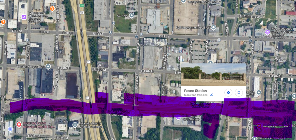
- On 18th St, a proposed East/West streetcar line directly connects to the existing Main St line and continues to numerous Southwest Boulevard & Crossroads businesses.
(Also 2 blocks from the crossroads: 18th St and Truman St edges) - 5 blocks from the East Village Transit Center: In addition to direct Park ‘n Ride options, a circular can be established through there, Power & Light, and The Crossroads.
- Troost is experiencing a major renaissance throughout its length, and has a max line.
- With the extra room, it can have a dedicated stop along any true light rail lines added along eastbound I-70, or the right of way for the KC Terminal Railway Corridor along 20th St.
- Additional Development opportunities West of Troost (7.37 acres) and north of Truman Road (5.22 acres). NOT COUNTING city-owned “Streets” between lots.
- On 18th St, a proposed East/West streetcar line directly connects to the existing Main St line and continues to numerous Southwest Boulevard & Crossroads businesses.

The green highlight is additional development or parking options.
Blue is the Baseball Museum (East/Right Current; South/Bottom is new).
Yellow is the East/West exits off of I70 at Paseo.
Top: Left of green is the Truman exit off of 71/49,
4 and 5 blocks south of Orange is the 22nd Street & Paseo exits from 71/49.
9 blocks north of orange is the Paseo exit off of southbound I35
Directly east is the Benton, 21st, and 23rd street exits off of I-70


For Reference:
- https://www.kcur.org/sports/2024-02-13/kansas-city-royals-stadium-crossroads-jackson-county-downtown-ballpark-baseball-arts-entertainment-district
- https://www.bizjournals.com/kansascity/news/2025/03/24/royals-washington-square-park-baseball-contract.html
- https://www.kctv5.com/2024/02/13/royals-relocate-club-announces-move-truman-sports-complex-crossroads/
- https://theclio.com/entry/142930
- https://www.mlb.com/news/kansas-city-royals-unveil-new-stadium-renderings-economic-data
- https://www.kctv5.com/2023/08/23/what-know-about-royals-east-village-proposal/
